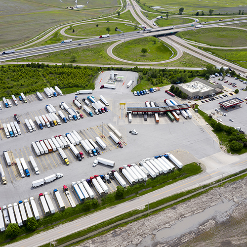
STOP & DURATION INSIGHTS
Stop Analytics
Get detailed insights on where, why, when, and how long vehicles stop with Altitude’s Stop Analytics.

Precise & contextual commercial vehicle data
Tailored for transportation planners, logistics managers, and infrastructure developers, our Stop Analytics Module leverages Altitude’s extensive mobility data. Gain detailed insights into vehicle stop patterns, including where, why, when, and how long vehicles stop. Our tool supports reliable planning and decision-making for all use cases, from optimizing infrastructure development to enhancing operational efficiency. With transparent data sources and methodologies, Altitude ensures you can trust the actionable insights provided for improved planning and effective solutions.
Features
Gain Comprehensive Stop and Domicile Insights
Tools for precise analysis of vehicle stop patterns and domicile duty cycles, offering detailed data for effective transportation planning and logistics management.


+
Detailed Vehicle Stop Data
Provides extensive insights into vehicle stop patterns, including where, and when vehicles stop. This supports planning for safer roadways, efficient curbside management, and optimized parking facilities.
+
Domicile Duty Cycle Metrics
Offers granular data on domicile duty cycles, including stop durations and distances. Essential for planning EV charging and alternative fuels infrastructure based on vehicle dwell times and movement patterns.
+
Segmented Vehicle Insights
Classifies data by vehicle class, vocation, industry, and fuel type. This segmentation enables targeted analysis and strategic planning tailored to specific vehicle segments and industries.
RELIABLE VEHICLE STOP AND DOMICILE DATA
Expand to More Effective Planning
Crucial for understanding vehicle stop patterns and domicile duty cycles, Stop Analytics and Regional Domicile Analytics enhance insights with granular, contextual data. These tools are vital for projects requiring high-confidence vehicle stop estimates and detailed domicile analysis, such as truck parking, electrification infrastructure, curbside management, and real estate site selection. These features enable transportation planners, utilities, and developers by providing a comprehensive understanding of where, when, and why vehicles stop, ensuring efficient infrastructure planning and resource allocation.